

A Powerful El Niño could shape Weather around the World this winter

An unusually strong warming of the Pacific Ocean is raising the possibility of a historic El Niño event, with potential consequences for global temperatures, rainfall, hurricane activity and winter snowfall.
A major shift in the Pacific Ocean is drawing the attention of climate scientists as the world moves deeper into autumn and prepares for winter. The developing El Niño is expected to strengthen further in the coming months, raising the possibility that it could become one of the most powerful events of its kind in more than seven decades.
According to the latest forecast from the US National Oceanic and Atmospheric Administration (NOAA), the chances of an exceptionally strong El Niño remain high. Its effects could extend well beyond the Pacific, influencing weather patterns across several parts of the world throughout autumn, winter and into spring 2027.
Although the precise effects will vary from region to region, the developing conditions have put rainfall, temperatures, tropical storms and seasonal snowfall under closer observation.
What Is Behind the Developing El Niño?
El Niño is a natural climate phenomenon characterized by warmer-than-usual sea surface temperatures in the central and eastern equatorial Pacific Ocean. It typically occurs every few years and can influence atmospheric circulation, changing weather patterns far from the ocean where it develops.
The latest observations indicate that the warming is becoming increasingly pronounced. During the past week, sea surface temperatures in parts of the eastern equatorial Pacific were around 2.3°C above average, with some areas recording anomalies as high as 4°C.
These figures point to an exceptionally strong warming event. However, a single day's temperature reading does not determine whether an El Niño will set a new historical record. NOAA relies on three-month averages and a relative ocean temperature index to assess the phenomenon more consistently.
Based on its latest outlook, NOAA has indicated an 83% chance that the October to December period will feature an El Niño stronger than previous events recorded since 1950. The forecast signals a significant possibility of a historic event, although its final strength remains uncertain.
Why Does a Warmer Pacific Matter?
The Pacific Ocean plays an important role in the Earth's climate system. When its surface waters become unusually warm, they release additional heat into the atmosphere and influence the movement of air, moisture and pressure systems.
These changes can affect where rain falls, how temperatures develop and how storms form. Some regions may experience wetter conditions, while others could face prolonged dryness. The effects also evolve over time, meaning that the consequences of El Niño are not necessarily felt everywhere at once.
El Niño is only one of several factors influencing weather. Other ocean conditions, atmospheric patterns and long-term climate change also contribute to the conditions experienced in individual regions.
Nevertheless, stronger events tend to increase the likelihood of familiar El Niño-related weather patterns, making the coming months particularly important for seasonal forecasting.
Atlantic Hurricane Activity Could Remain Limited
One of the clearest ways El Niño can influence weather is through tropical cyclone activity. In the Atlantic Ocean, stronger El Niño conditions often increase wind shear, which can disrupt the development and organization of hurricanes.
This does not mean that hurricanes cannot form. Rather, the atmospheric conditions can make it more difficult for storms to strengthen and persist.
The 2026 Atlantic hurricane season has shown signs of relatively limited hurricane development. According to the reported figures in the latest update, nine named storms had formed, but only one had reached hurricane strength by early October.
The first hurricane of the season, Isaiah, reportedly reached hurricane status on October 7, making it an unusually late first hurricane in the satellite era.
If the current pattern continues, the Atlantic could finish the season with fewer hurricanes than usual. However, seasonal outcomes are not determined by El Niño alone, and a quieter season cannot be guaranteed.
The situation is different in the eastern and central Pacific, where El Niño often favors tropical cyclone development. Warmer ocean waters and changes in atmospheric circulation can create more supportive conditions for storms in these basins.
What Could Winter Look Like Across the United States?
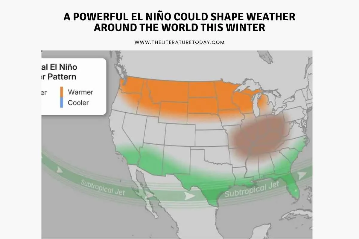
El Niño's influence on US weather often becomes more apparent between December and March. During this period, changes in the jet stream, a fast-moving current of air high in the atmosphere, can redirect storm systems and alter the distribution of rainfall and temperature.
A stronger El Niño commonly strengthens the southern branch of the jet stream. This can bring more frequent storm systems and increased precipitation to parts of the southern United States.
A Wetter Winter in the South
Parts of California, the Desert Southwest, the southern states and the Southeast could experience wetter-than-average conditions. Florida may also see increased rainfall.
In areas where temperatures are sufficiently low, these weather patterns can contribute to snowfall. However, heavier precipitation does not automatically mean more snow. Local temperatures and the timing of individual storms will determine whether the precipitation falls as rain or snow.
For regions that depend on winter precipitation to replenish reservoirs and support agriculture, changes in rainfall could have important implications.
Milder Conditions across the North
The northern United States, including parts of the Northwest, northern Rockies, Northern Plains and Midwest, often experiences milder and drier winters during strong El Niño events.
If this pattern develops, some areas could see fewer cold outbreaks and reduced snowfall compared with their seasonal averages. Milder temperatures may also reduce heating demand in some locations.
These are broad seasonal tendencies rather than precise predictions. Individual cold spells and snowstorms can still occur, even during a strong El Niño.
Hawaii Could See Shifting Rainfall Patterns
Hawaii can also experience changes in rainfall during El Niño years. Wetter winter conditions are possible, followed in some cases by a drier period in the subsequent year.
The exact outcome depends on how atmospheric circulation develops over the Pacific, making continued monitoring important for communities that rely on predictable rainfall.
The Effects Extend Beyond North America
El Niño is a global climate phenomenon, and its influence can reach regions far from the Pacific Ocean.
Australia and Indonesia, for example, often face an increased risk of below-average rainfall during strong El Niño events. These conditions can contribute to drought, affect agricultural production and place additional pressure on water supplies.
Other parts of the world may experience changes in seasonal rainfall and temperatures, although the direction and intensity of those changes depend on local climate conditions.
For this reason, scientists examine El Niño alongside other climate indicators rather than treating it as a complete explanation for every unusual weather event.
What Should We Expect in the Coming Months?
The developing El Niño could become a major influence on global weather as 2026 draws to a close and 2027 begins. Its potential strength makes it an important development for meteorologists, agricultural planners, water managers and communities preparing for seasonal weather risks.
However, a strong El Niño does not mean that every expected impact will occur. Seasonal forecasts describe probabilities and broad patterns, not guaranteed outcomes for particular cities or individual weeks.
The most useful approach is to follow updated forecasts from recognized meteorological agencies and pay attention to regional warnings as the season progresses.
For now, the Pacific's unusual warming offers a reminder of how closely connected the Earth's oceans and atmospheres are. What begins as a change in ocean temperature can influence rainfall, storms and winter conditions thousands of kilometers away.
Whether this event ultimately becomes the strongest El Niño on record remains to be seen. What is clear is that the coming months will be important for understanding its strength, its reach and the weather patterns that may follow.






Comments (0)